


Patterns favor colder, snowier winter for Minnesota
Description
Cue the polar vortex?
<figure class="figure figure-none figure-full"><source type="image/webp" /><source type="image/jpeg" /> <figcaption class="figure_caption">
We may need to keep our shovels, snowblowers and polar fleece handy this winter across Minnesota. Several ocean and atmospheric factors seem to be in place for a colder and snowier winter across the northern United States. That could mean multiple subzero polar vortex outbreaks this winter.
<figure class="figure figure-none figure-full"><source type="image/gif" />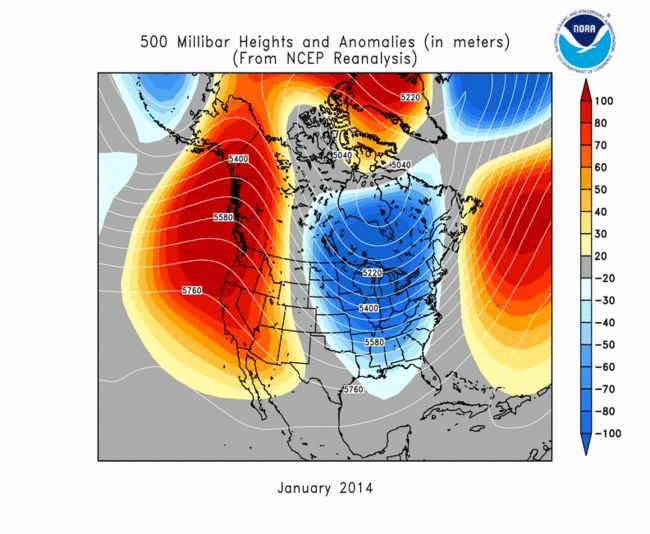 <figcaption class="figure_caption">
Multiple signs
I’ve been talking and writing for a few weeks now about the combination of factors that favor a colder, snowier winter.
Record warm water in the North Pacific, a developing La Niña in the tropical Pacific and extensive Siberian snow cover in October all tend to favor colder, snowier winters in Minnesota and the northern United States.
<figure class="figure figure-none figure-full"><source type="image/webp" /><source type="image/jpeg" />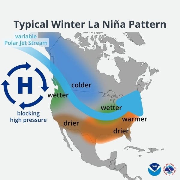 <figcaption class="figure_caption">
The National Oceanic and Atmospheric Administration’s official winter outlook dropped Thursday and concurs that a colder and potentially snowier winter is more likely than not for the northern United States.
<figure class="figure figure-none figure-full"><source type="image/webp" /><source type="image/png" />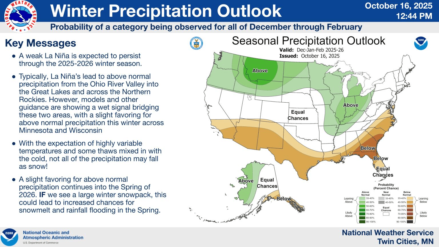 <figcaption class="figure_caption">
Here’s a clip.
Temperature
Warmer-than-average temperatures are favored from the southern tier of the U.S. to the eastern Great Lakes, eastern seaboard, New England and northern Alaska. These probabilities are strongest along the Gulf Coast and for most of Texas.
Below-average temperatures are most likely in southern Alaska, with below-average temperatures slightly favored from the Pacific Northwest to the northern High Plains.
Precipitation
Wetter-than-average conditions are most likely in the Great Lakes states, and above-average precipitation is also favored in northern and western Alaska, the Pacific Northwest and across the northern tier of the U.S. These probabilities are strongest in portions of Ohio, Indiana and Kentucky.
I wrote last month about record warm ocean temperatures in the northern Pacific Ocean. The last time we observed water this warm was the winter of 2013 and 2014.
<figure class="figure figure-none figure-full"><source type="image/webp" /><source type="image/png" />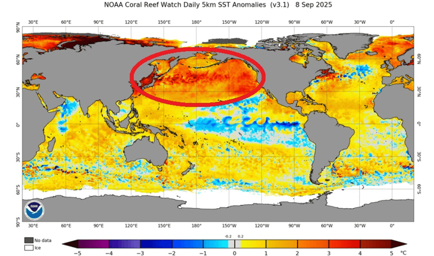 <figcaption class="figure_caption">
That winter was the ninth coldest on record in Minnesota. The Twin Cities had 70 inches of snow and 53 nights of subzero temperatures!
<figure class="figure figure-none figure-full"><source type="image/jpeg" /> <figcaption class="figure_caption">
Here’s a clip from the Minnesota State Climate Office about that brutal winter.
The 2013-14 winter was noteworthy on many counts. The 53 nights of at or below zero temperatures in the Twin Cities tied for 5th most on record 1872-73. International Falls had 92 at-or-below-zero readings, tying 1977-78 for the No. 1 spot, and some far northern stations like Kabetogama, Norris Camp, and Babbitt fell to 0F or lower more than 100 times.
Another measure was the extremely low wind chill temperatures. A generation of elementary and high school children will not forget January 2014. This was the month that had five days of school canceled due to the wind chills in the Twin Cities. The lowest wind chill temperature was -48 at the Twin Cities on Jan. 6 and, for the state it was -63 degrees at the Grand Marais Airport.
The meteorological winter (December-February) wound up being the ninth coldest on record in the Twin Cities going back to 1872-73, and the extended winter (November through March) was the seventh coldest for the whole state, going back to 1895. Indeed, the winter of 2013-2014 will be the standard against which others are compared for many years.
Our current weather patterns offer no guarantee this winter will be as bad as the 2013-14 winter. But signs are pointing toward a rigorous winter ahead.
Stay tuned.


 United States
